
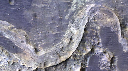
(Courtesy of NASA/JPL/Univ. Arizona/Univ. Chicago)
Rather like a swollen river overflowing its banks, the story of water on Mars keeps on rising and spreading in quite unpredictable ways.
While the planet is now inarguable parched — though with lots of polar and subsurface ice and, perhaps, some seasonal surface trickles — data from the Curiosity rover, the Mars Reconnaissance Orbiter and other missions have proven quite reliably that the planet was once much wetter and warmer. But how much wetter, and for how long, remains of subject of hot debate.
On one side, Mars climate modelers have struggled to find mechanisms to keep the planet wetter and warmer for more than it’s earliest period — perhaps 500 million years. Their projections flow from the seemingly established conclusion that Mars lost much of its atmosphere by 3.5 billion years ago, and without that protection warmer and wetter appear to be impossible.
But the morphology of the planet, the gorges, the fossil lakes, the riverbeds and deltas that are visible because of 21st century technology and missions, appears to tell a different and more wide-ranging story of Mars water.

Credit:NASA/JPL-Caltech/MSSS
And now, in one of the most expansive interpretations of the Martian water story, University of Chicago planetary scientist and Mars expert Edwin Kite and colleagues report in a Science Advances paper that the planet not only once had many, many lakes and rivers, but that they were filled as part of a water cycle involving precipitation, rather than primarily through the sporadic melting of primordial ice as a result of incoming meteorites or other astrophysical events.
What’s more, they write, the rivers continued to sporadically flow well past the time when the Martian surface has been assumed to be dead dry.
The era when Mars has been most often described as going from wet-to-dry is around 3.5 billion years ago, but their interpretation of when precipitation-filled rivers stopped running is about 3 billion years ago. In other words, Kite’s team now says the rivers ran — often quite actively — for more than one billion years.
The new study catalogued and studied more than 200 these rivers to conclude that the significant river runoff persisted on Mars later into its history than previously thought. According to the study the runoff was intense: rivers on Mars could be twice as wide as those on Earth today and were often “raging” with water. They also could be found at hundreds of locations around the planet.
To better understanding Martian precipitation and the resulting rivers, Kite and his colleagues analyzed photographs and elevation models for Martian riverbeds spanning over a billion years. This provided information about the water running through them and the climate that produced it.
For example, the width and steepness of the riverbeds and the size of the gravel tell scientists about the force of the water flow, and the quantity of the gravel constrains the volume of water coming through.
Perhaps most surprising, Kite and his colleagues found that rivers that ran as late in Mars history as three billion years ago appeared to flow with similar force and volume as earlier rivers.
“You would expect them to wane gradually over time, but that’s not what we see,” Kite said in a statement. “The wettest day of the year is still very wet.”
“It’s already hard to explain rivers or lakes (on Mars) based on the information we have,” he said. “This makes a difficult problem even more difficult.”
Mars is crisscrossed with the distinctive tracks of long-dead rivers. NASA’s spacecraft have taken photos of hundreds of these rivers from orbit and, when the Mars rover Curiosity landed in 2012, it sent back images of pebbles that were rounded and thus tumbled for a long time in the bottom of a river.
But it’s a puzzle why ancient Mars had liquid water. Mars had an thin atmosphere quite early on and the planet was only receiving a third of the sunlight of present-day Earth from the less-powerful early sun. That shouldn’t have been enough heat to maintain liquid water.
“Even on ancient Mars, when it was wet enough for rivers some of the time, the rest of the data looks like Mars was extremely cold and dry most of the time,” Kite said. “Yet rivers still ran.”
Clearly, it’s remains a puzzle.
It’s possible the climate had a sort of “on/off” switch, Kite speculated, which tipped back and forth between dry and wet cycles. And it seems likely that some kind of greenhouse effect was playing a role. But nothing definitive has been put forward.

“Our work answers some existing questions but raises a new one. Which is wrong: the climate models, the atmosphere evolution models, or our basic understanding of inner solar system chronology?” he said. The last possibility refers to where Mars might once have or orbited and when.
He also said that perhaps the rivers are older than researchers think. Or perhaps Mars dried out much faster than current theories suggest. But Kite says some unexplained process may have also kept Mars warm long enough for large rivers to flow even after most of its atmosphere had disappeared.
“All three options are uncomfortable,” Kite says. “All three of these solutions would require significant revision of our current understanding.”
In their study, Kite and colleagues looked only at river channels that appeared to be precipitation-fed. That means they set aside waterways with different origins, like those formed by ice melted by incoming meteorites and other non-climate causes. These rivers, with often deep gorges, are often termed the results of “megafloods.”
“Catastrophic outflow channels certainly exist,” Kite wrote in an email. “There are also features that could be carved by spring water, although that’s debated. We ignored both catastrophic outflow channels and arguably spring-carved channels, and focused on the ones that are precipitation (rain or snowmelt) fed.”
Mars is also known to have large reservoirs of subsurface ice and even liquid water beneath its surface. There remains debate about this, but many scientists see evidence of small amounts of water still trickling, even in Gale Crater.
The possible presence of liquid water — and the highly unlikely but still conceivable possibility tht some form of microbial Martian life remains — has kept NASA’s missions to Mars away from fossil deltas and other potentially wet locations. The reason why is that scientists fear that Earthly contamination from the vehicle could forever change the character of any remnant life on Mars.
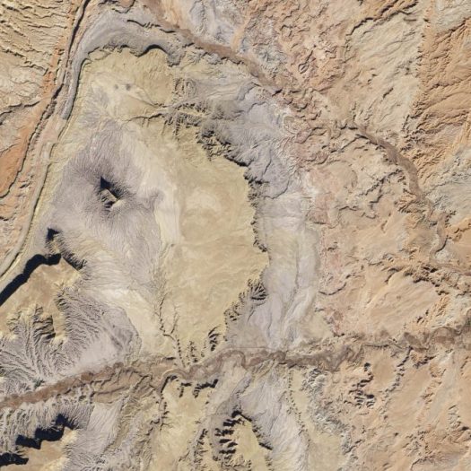
The next Mars mission, however, will be going to Jezero Crater, which does contain a delta formation. With increased confidence in how precisely NASA can nail the landing, mission managers were convinced that Jezero offered many geological, geochemical and astrobiological targets and could be reached without landing in a restricted “special region,” as defined by planetary protection.

Jezero crater holds a fossil river delta, which may have concentrated and preserved signs of life.
(NASA/JPL/JHUAPL/MSSS/Brown University)
The 2020 mission is the first since the Viking missions of the mid 1970s to have a formal biosignature and life detection component, so being in the in a once-watery environment is important.
Scientists believe an 820-foot-deep (250 meters) lake filled the crater at some point in the period from about 3.9 billion to 3.5 billion years ago. Jezero also features a prominent delta once fed by several rivers. Water flowing through this system deposited tons and tons of sediment over the eons. That makes the search for signs of ancient life promising, if still a long shot.
