NASA’s long-time motto for exploring Mars has been “Follow the water.” That has changed some in recent years, as the presence of long-ago H2O has been confirmed in many locales around the planet. Moving on, the motto today is more “Follow the organics” — the carbon-based building blocks of life — in the search for habitable environments and maybe signs of ancient life.
But water remains crucial to any discussion of habitability on Mars, and so a new set of global water maps from the European Space Agency, ten years in the making, is both useful and intriguing.
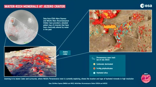
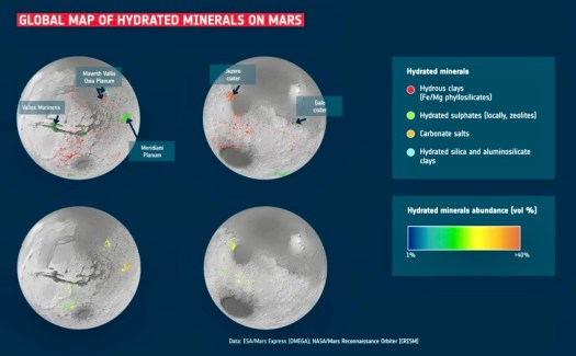
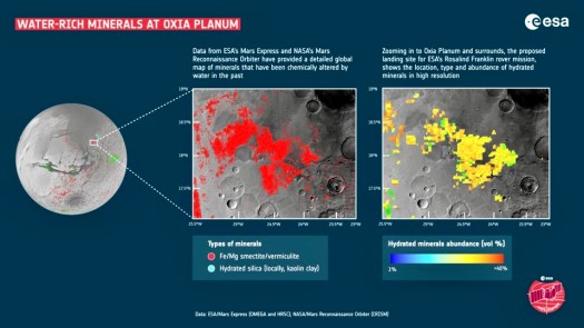
Specifically, the map shows the locations and abundances of these aqueous minerals — rocks that have been chemically altered by the action of water in the past, and have typically been transformed into clays and salts.
And the message that the maps deliver, said planetary scientist John Carter, is that these hydrated minerals are common across many parts of the planet.
Ten years ago, planetary scientists knew of around 1, 000 water-altered outcrops on Mars, he said. This made them interesting as geological oddities.
But the new map has reversed the situation, revealing hundreds of thousands of such areas in the oldest parts of the planet.
“This work has now established that when you are studying the ancient terrains in detail, not seeing these minerals is actually the oddity,” says Carter, an assistant professor at the Institut d’Astrophysique Spatiale (IAS) in France.
Now, Carter said in a release, the big question is whether the water was persistent or confined to shorter, more intense episodes. While not yet providing a definitive answer, the new results certainly give researchers a better tool for pursuing the answer.
“I think we have collectively oversimplified Mars,” says Carter, who was lead author in a paper published in the journal Icarus.
He explained that planetary scientists have tended to think that only a few types of clay minerals on Mars were created during its wet period — roughly 3.5 billion to 4 billion years ago — then as the water gradually dried up salts were produced across the planet.
This new set of maps, using data from two Mars orbiters, shows that it’s more complicated than previously thought.
While many of the Martian salts probably did form later than the clays, the map shows many exceptions where intimate mixing of salts and clays can be found, and some salts that are presumed to be older than some clays.
“The evolution from lots of water to no water is not as clear cut as we thought, the water didn’t just stop overnight,” he said.
“We see a huge diversity of geological contexts, so that no one process or simple timeline can explain the evolution of the mineralogy of Mars. That’s the first result of our study. The second is that if you exclude life processes on Earth, Mars exhibits a diversity of mineralogy in geological settings just as Earth does,” he said.
As is so often the case, the closer that researchers look the more complex Mars’s past becomes.
Many of the water-altered mineral deposits were found inside craters and in the southern half of Mars, often called the “southern highlands.” That’s where the Mars that can be studied is at its oldest and least changed by lava flows.
While Carter and his team found some water-altered minerals in the northern hemisphere, they were generally at the floor of small impact craters. These craters serve as windows into Mars’ past by penetrating down through the lava flow, as well as showering chunks of the underlying crust across the nearby surface.
The northern hemisphere is considerably lower than the southern highlands and is generally covered by ancient lava. Some have argued for the presence of an ancient “northern ocean” that covered much of that hemisphere. This theory proposes that the north was the site of a very large asteroid impact long ago that dug deep into Mars and later filled with water.
But Carter said he did not find evidence of what might have once been an ocean. He said that in the 10 craters in the northern plains where hydrated minerals were found, they also found mafic minerals — deposited via volcanoes – such as olivine. But most of the detected olivine, which is easily altered by liquid water, was unaltered. To Carter, that strongly suggested that a large ocean was never present.
The new water maps and results are presented in a pair of papers written by Carter, Lucie Riu and colleagues. Riu is now an ESA Research Fellow at European Space Astronomy Centre in Madrid.
With the basic detections in hand, Riu decided to take the next step and quantify the amounts of the minerals that were present. “If we know where, and in which percentage each mineral is present, it gives us a better idea of how those minerals could have been formed,” she said in the release.
This work also gives mission planners some great candidates for future landing sites and for human habitations.
The aqueous minerals, for instance, still contain water molecules, which could someday be extracted for use. Together with known locations of buried water-ice, they could provide possible locations for “In-situ Resource Utilisation,” key to the establishment of human bases on Mars.
Clays and salts, which would be present because they are formed in the presence of water, are also common building material on Earth.
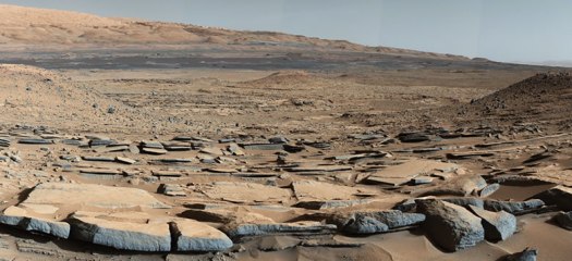
But before humans go to Mars, the aqueous minerals provide rich locations for scientists. As part of this mineral mapping campaign, the clay-rich site of Oxia Planum was discovered. These ancient clays include the iron and magnesium rich minerals of smectite and vermiculite.
Not only can they help unlock the planet’s past climate, but they are perfect sites to investigate whether life once began on Mars.
As a result, Oxia Planum was proposed and finally selected as the landing site for ESA’s Rosalind Franklin rover, scheduled to launch later this decade.
